
Bringing the working waterfront online
Bringing the working waterfront online
 Plan · Discover · Dock
Built for boaters. By boaters.
Plan · Discover · Dock
Built for boaters. By boaters.
The boating app that answers the questions you actually have: worth going out? where to? room to tie up? An integrated boating experience built for Narragansett Bay boaters.
Portside and the HarborFlo dock console go into beta testing this fall. The first docks go live for the 2027 season.
Run part of the waterfront?
The problem
Your chartplotter is excellent at what it was built for: getting you there. It was never meant to be a weather service, so you add one. That's two. Now you're thumbing between them with a wet hand while the bow slams.
Then you decide to stop - lunch ashore, an ice cream in Bristol - and there is no app for that at all. The chartplotter's database thins out the moment you cross the shoreline, and Google knows the hours and the reviews but nothing about arriving by water: is there a dock, is it free, how long can you stay, can you reserve or is it first come, and is there room right now?
Fuel is worse. Marine prices are published almost nowhere, and the fuel dock in your chartplotter was last updated in 2017.
That's app fatigue, and it's at its worst in the one place you can't pull over - you're floating. So plenty of trips never happen, and not because the bay was rough: because nobody could answer three simple questions before casting off. Worth going out? Where to? Where to tie up, and is there room?
Portside answers all three from one screen. See the bay live before you cast off.

How it works
Portside is the first destination planner of its kind. It is not something you stare at while it drains your battery. It stays quiet and speaks up only when something changes on your trip - a dock you are watching opens up or fills up, or the weather turns - so your eyes stay where they belong: on the traffic around you, the water ahead, and the bay you came out to enjoy.
Trip watching and its alerts are in development.
And it follows a day on the water in the order a day actually happens.

Dock
A boater motors across the bay on a Saturday, finds the dock full, and turns around. The dock loses a customer, the restaurant loses a table, and the boater loses an afternoon. Plenty never set out at all - and the ones who got turned around once are in no hurry to try again. And plenty more never knew there was a dock to go to: which town takes a visiting boat, what an hour costs, how long they can stay, and what street it leaves them standing on. The bay is not short on boater demand. It is short on visibility and certainty.
Every destination card carries its dock - its own, or the nearest public one - and shows its status: how many feet are open along the face, or which slips are free, and how confident that is. Confirmed, four minutes ago.
Then Portside does whatever that dock allows. Reservable, so you reserve it. First come, first served, so you watch it - and a push notification the moment it opens up, or fills. A charge or a check-in, so your boat details and the payment are sent in one tap.
Boaters help boaters. Say when you expect to leave and the next boater sees it - on a first-come dock, somebody willing to say so is the only real availability there has ever been. Extend without walking back, tip the attendant, get a nudge before your time runs out - and when you step off, one tap opens the walk from your cleat to your destination. Google wasn't very good on the water. It's amazing on a street though.

Dock & dine
Boaters often do not pick their favorite waterfront restaurant - they pick the dock they think they can tie up to. So the dock sits beside the table: the space, and whether there's a table tonight. Settle it before you cast off, or from the water - so you might end up back at your favorite restaurant after all.
The restaurants above are fictional and every figure beside them illustrative. Showing live table times beside dock space takes an integration with the booking platforms, and we are in conversations to put that in place. In the meantime some platforms offer embeddable booking tools that can run inside Portside; otherwise it opens the restaurant's own page.
Discover
Land apps list everything. Boating apps list almost nothing useful ashore. Portside's hybrid map shows only what is reachable by boat - a dock of its own, or a public dock within walking distance - and every one of them is checked by hand. The rest of the land map stays gray, there for context and navigation.
Toggle destination types on the map - public docks, fuel, restaurants, treats and shops - and a color ring on every dock shows its state: open, filling or full.
Tap a destination for the glance - what it is, the dock that serves it, the walk from the cleat, and whether that dock has room. If the closest one is full, it moves to the next dock within walking distance. Tap again for the full record. Search the map like a chart or browse it like a guide.

Plan
Tell it when you're leaving and where you're going, and Portside finds your clear windows - dry hours inside the wind range you set for your own boat, checked along the whole route at the hour you will be there, not just at the dock. Or don't name a place at all. Say wherever conditions are best, and it answers the other way round: which places hold up for the hours you have, and where you could actually get to. Then it keeps watching after you cast off and sends you a push notification if the plan stops working.
And because wind only hints at what the water is doing, Portside is adding forecast wave height, period and direction for the bay itself - read against your boat and your heading, in plain language: "small waves stacked close together - wet, bumpy ride" or "gentle rollers far apart - a comfortable cruise." The same afternoon can be flat in Warwick and a foot of chop in Newport, and that is the difference you will be able to see before you go.
Trip watching, alerts and the departure-time suggestion are in development. Wave forecasts will come from NECOFS, the Northeast Coastal Ocean Forecast System, reached through MARACOOS OceansMap. Credits below.


Dangerous-condition alerts - advisories, lightning, fog - are free for every boater, always. The National Weather Service marine forecast displays verbatim.
Portside Pay
No boating app has ever shown a marine fuel price you could trust. Nobody has ever had a line to the fuel dock itself, so every number is secondhand - and some have not been touched in nearly a decade. Boaters guess - and pay whatever is on the pump they happened to reach, when a better price was five miles away the whole time.
Portside Pay connects to the payment processor the dock already uses, and the price publishes itself every time somebody fills up. That same connection carries the dock itself: how much space is open, and when it is full, an estimated time remaining.
And paying stops being the awkward part. Today your card goes over the rail and walks to the register without you. Instead the total reaches your phone the moment the pump stops - one tap with your wallet, nothing handed across the water - and the receipt arrives digitally, which for fuel is the one a boater might actually want to keep.
Tip the attendant from the same screen. The person catching your lines has earned one, and almost nobody carries cash on a boat any more - or they started the day with some and ran out three stops ago. Every fill then lands in your own fuel log: what you paid, where, and when. One app, one wallet, the whole bay.
The rethink
Most boating apps open on a map of wherever you are standing and wait for you to do the work. Portside opens on your water - conditions at your home port, the forecast in plain words, and what is open around you - then follows the boat once you are underway.
We are not building a chartplotter. Yours is good at its job, and this does not compete with it. Portside is everything the chartplotter was never for: the decision to go, the place to go, and what is waiting when you get there.
And it is built to live in your pocket. Your phone should still have a charge when you need it, so Portside is built not to be the thing that spent it. It does not run in the background and does not follow you when it is closed - screen off means Portside is off. An app that is not running cannot drain your battery, and for most of a trip Portside is not running: you open it for a glance and put the phone away. Trip watching will run on our server rather than on your phone, and alerts arrive the way every other notification on your phone does - through the one connection it already keeps open - so nothing of ours has to be running to receive them.
Trip watching and its alerts are in development. Battery use depends on your screen brightness, your phone and your signal.

For the waterfront
Every known destination on the bay is on the map. Pick your side of it:
On summer weekends demand outruns the space - while other boaters skip the trip entirely because they cannot see whether there is room, and plenty never knew they could tie up in the middle of town at all. Portside puts the dock on every boater's screen, live.
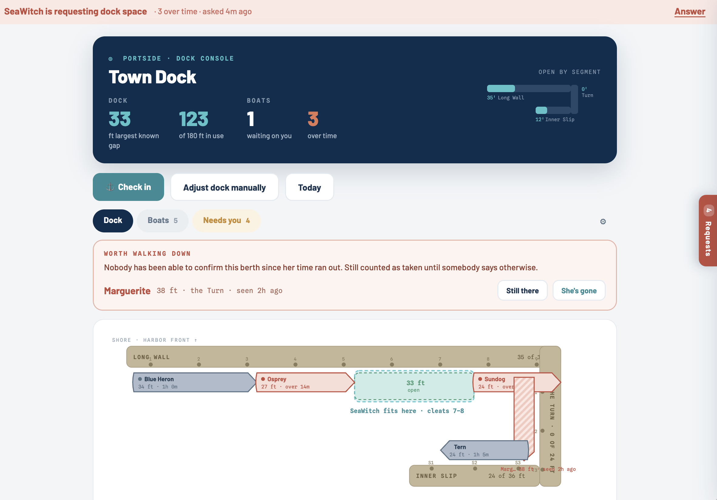
Tap a boat in, tap it out - that is the whole job, and it becomes the live feed. Boaters need no app: hold the tablet up and they scan the code and pay on their own phone, text or email them the same link, or check them in by hand on the console. Overstays are flagged automatically instead of absorbed. Boaters extend and pay from the restaurant table instead of rushing back, and the ones who circle away today get an alert the moment a spot opens. Payments integrate securely with the payment processor the city already uses and run through its own account - receipts still carry the city's name. It costs the city nothing - Portside is paid for from the other side of the waterfront: sponsoring businesses and restaurants, premium boater subscriptions, and the private docks, fuel docks and mooring operators who use its tools.
A boater choosing between seven waterfront restaurants doesn't pick the best menu - they pick the dock they think they can tie up to. "Can we come by boat?" is the question your staff answers all summer, and the answer changes by the hour. When a boater guesses wrong, the covers just never arrive.
Your card carries the menu, the walk from the cleat to the door, and - where docks take part - whether there is room right now. If you have your own dock, live availability costs you nothing and is free for pilot restaurants in the 2027 season. If your customers arrive at the town dock, your card shows its status and the walk. Either way, boaters stop guessing about you.
Boaters cannot see your price or whether the pump is clear, so they gamble - and some motor off in the wrong direction while your dock sits open. Portside shows a live price and live status, puts the total on the boater's phone the moment the pump stops, takes the tip with it, and sends the digital receipt boaters actually want to keep.
A guest ties up, scans the QR code on the dock, and is checked in - the clock starts on its own, time limits enforce themselves, and overstays are flagged without anyone staffing the dock. Someone gets an alert only when something needs a person. Charge for dockage or offer it free to customers; either way you finally see how the dock is used, for a fraction of what booking marketplaces charge.
Renting a guest mooring today means motoring buoy to buoy - to see what is open, to collect payment, to find out who has been sitting on a ball for free. With Portside, boaters find and rent a mooring in the app, get guided to their ball, scan the QR code on it, and check in and pay from the boat - and the office sees who is where, who has paid, and which balls are earning.
The ledger also flags what does not add up: a boat that checked in and never checked out, a stay running past what was paid for, a ball that should be open when the next boater arrives and is not. And when weather is coming, the office knows at a glance which balls have boats on them and can reach every one of those boaters with a single storm alert - one list and one message, instead of a workboat sweep of the field.
Beta testing this fall, piloting for the 2027 season, Narragansett Bay first. Nothing to buy and nothing to install.
Talk to HarborFlo